Onyx Space is authorized to market and sell Sateherd’s TT&C Operating Software System (Telemetry, Tracking and Command)
The software systems complement and work together to accomplish the tracking, control, monitoring and data processing of satellites and ground station equipment. TT&C operating software system has completed rapid access and adaptation to various satellites and ground equipment, and can ensure the stable, efficient and swift mission operation.
Technical architecture
Our space TT&C operating software system has the most advanced and mainstream internet development technology. The software platform is divided into front and back-end and adopts B/S architecture. The front-end is developed using VUE allowing users to get started with ease. The back-end uses JAVA language development, follows J2EE technical specifications, assuming the characteristics of cross-platform and security. Each system adopts Microservices architecture to facilitate the subsequent integration and secondary development of each service. The space TT&C operating software system uses cloud server, cloud storage, containerization (K8S) and other cloud native technologies for operations and management. The hardware has dynamic capacity expansion, and the software has features such as high availability, elastic scalability, and load balancing. In addition, user data is backed up to ensure data security and recovery.
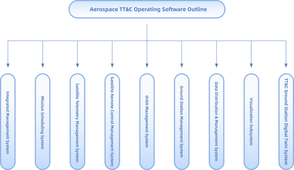
Integrated Management System
The integrated management system is the foundation of the TT&C operating software system. It includes the basic functions for maintenance and management: user information, access rights allocation, satellite information and ground station information. It also provides the relevant basic data interfaces to support the business in development of other systems.
The security and access rights of the space TT&C operating system are jointly completed by the integrated management system and gateway service. The open source security permission framework (SA-Token) is selected as the core component of permission control, and the gateway service is responsible for integrating the components to achieve the purpose of permission control and authentication. The gateway service also does the request forwarding and data response for the various systems.
Task Scheduling System
Process and store satellite forecast information from the orbit management system, configure scheduling rules for users, ground stations and satellites, and automatically complete the scheduling using genetic algorithms, while supporting manual mode scheduling and tracking settings. The system monitors the progress and status of task execution in real time and reports the results. It can display the status of subsequent tasks in a Gantt chart and satellite transit orbit information in a map.
Satellite Telemetry Processing System
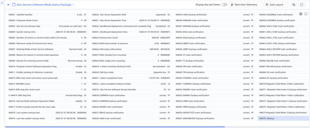
The satellite telemetry processing system ensures the processing, storage and display of various types of satellite telemetry data. The software allows for flexible configuration and adjustment of various telemetry parameters, and adopts hot loading to achieve real-time effect. The interface can display real-time telemetry data in curves and tables. It supports custom telemetry interface, users can drag and configure to combine and display the key telemetry of various satellites, for intuitive analysis of the real-time satellite status.
The satellite telemetry processing system uses the time series database, utilizing the technical characteristics of database and table, data compression, stored source code, which are combined with the batch and asynchronous multi-thread storage of the program, which greatly improves the read and write performance of telemetry data and disk consumption, enhancing the response speed and user experience.
Satellite Remote Control Management System
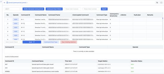
Satellite remote control management system bears the core responsibility of satellite command processing and uploading. The system is able to configure and process direct commands, indirect commands and parametric commands of various satellites, and supports batch import and management of commands and imaging parameters. Additionally, it has reverse programming and verification functions for commands. Commands can be completed automatically or manually according to mission and satellite telemetry information. The software interface can display in real time the command uploading status, time, abnormality information and post-query. The system facilitates technical personnel in swift intervention and location of problems.
Orbit Management System
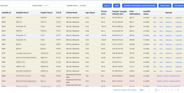
Orbit calculation includes many basic tools such as coordinate system conversion, time system conversion, two-line transient root conversion, etc. It supports HPOP, J2, SGP4 output and other prediction models in a variety of ephemeris, supports the calculation of special events (such as earth shadow and moon shadow) and pointing of satellites to targets and celestial bodies. It is able to calculate the relative distance between satellites or different orbits of the same satellite. It supports collision warning risk calculation and provides the corresponding animation simulation system. It supports orbital control calculation of semi-major axis, inclination, ascending node and other parameters, and supports the calculation of the substellar point longitude and local time keeping at descending node for the return of LEO to SSO. It supports post-control thruster calibration and recording.
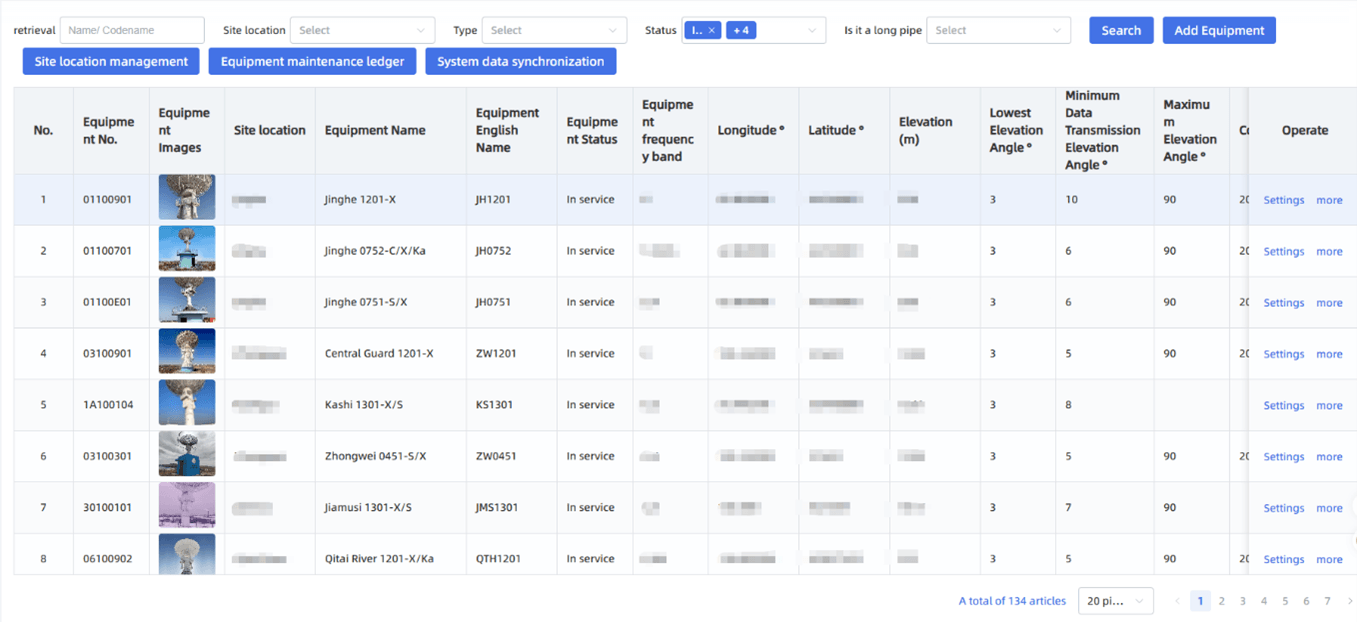
Ground Station Management System
The Ground Station management system is capable of remote monitoring and control of large-scale ground stations, automatic equipment scheduling and management , automatic operation of ground stations, remote real-time status monitoring and control of various equipment, automatic remote control of equipment and automatic task execution according to the task plan. In addition, the status of equipment and task execution can be reported by voice in real time to achieve intelligent guarding.
Data Relay System
The data relay system resolves data transmission and communication between the TT&C operating software system, the ground station and the users, acting as the core of the system. The system is responsible for the conversion of TCP/UDP protocols and can automatically deal with the problems of TCP sticky packets and packet splitting.
The network communication module of the data relay system is via Netty framework, supports NIO, zero-copy, Reactor master-slave multi-threaded model, ensuring absolute reliability and leadership technically.
Visualization System
The visualization system software consists of two main segments: satellite simulation and 3D demonstration.
Satellite simulation is used mainly to display the on-orbit operation status of the satellite. Orbit information is used to simulate and demonstrate the 3D on-orbit operation status of the satellite, and display the current flight status of the satellite and the surrounding environment in a multi-dimensional form. It is based on the Cesium visual 3D graphics library and supports coordinate system conversion.
The 3D demonstration is used mainly to display the current scenario: sub-satellite point data, TT&C Station location, tracking range, tracking time, dawn and dusk line and other information in real time. It supports map movement, scaling, longitude-latitude grid display and 3D switching. It is able to install and load satellite custom models, 3D scene configurations and control playback speed, giving users a deep and realistic demonstration of the spatial situation.
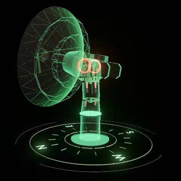
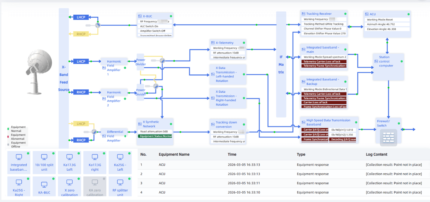
TT&C Station Digital Twin System
The TT&C station digital twin system uses U3D and digital technology to collect real-time data of the station’s antenna equipment, displays the position of the equipment in real time using 3D models, builds an all-round and multi-dimensional digital twin visualization platform by combining 2D and 3D visualization, and uses digital technology to monitor and control the operating status of the equipment in real time.
 Pricelist
The price of all modules is summarized in the following table:
Here is the table extracted from the image:
| Description | Price (USD) |
|---|---|
| Comprehensive Management System | 54,000 |
| Orbit Management System | 72,000 |
| Mission Planning System | 91,000 |
| Satellite Telemetry Processing System | 107,000 |
| Satellite Telecommand Management System | 86,000 |
| Ground Station Management System | 124,000 |
| Data Transmission | 98,000 |
| Operation Control System | 98,000 |
| Data Transfer | 66,000 |
| Visualization System | 50,000 |
| System Operation Monitoring | 34,000 |
| Installation and Commissioning (Remote debugging and connection) | Free |
| Training (On-site training for 1 person / 5 days) | 9,000 |
| Total | 889,000 |